Shady Grove Directions Yellow Map
How to get to Shady Grove using the yellow map
 shadyGoogleMAP2020
+
shadyGoogleMAP2020
+
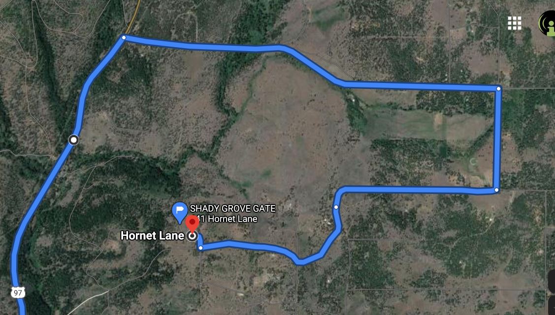
Directions to the Shady Grove <-- click on title for a Google Map
https://goo.gl/maps/auhTJih123P2
Follow Highway 97 North for 20 minutes - winding up hill up into the High Desert of Washington .... right past all the windmills and then right on past Goldendale, just stay on Highway 97. You do not turn left into the town of Goldendale which has two exits on your left. Just drive on by.
Turn right onto "Box Canyon Road - the yellow sign will say its a Dead End Road
After turning Right on Winduga Road (15 mph speed limit) follow this for about a 1/4 mile
Use this address for your online map search - it is actually the address to my neighbors place right by my private gate - Once you are this close you can find the Shady Grove campground .... the following address will take you to the gate:
510 Hornet Lane, Goldendale Washington
PLEASE NOTE:
Google Maps may suggest alternative routes ~and~ In this case these routes won't be exactly correct or accurate.
So use Google Maps for the General direction and to "compare where your GPS says you currently are" located.
Compare your Google Map --> to "my directions"
and if given a choice use "my directions" - see below.
One GPS snafo example is Google maps will tell you to turn right off of 97 at Three Creeks Road. [Also known as Three Creeks *Resort] (this about 18 miles past Goldendale) ...Well that is a private gated road, so DO NOT turn there as your GPS might tell you, instead stay on 97 up to mile marker 22 which is "Box Canyon Road" (directions below).
When driving up 97 --> Go past Goldendale on the left and then up the road 10 miles you will also go past "Three Creeks Resort" on the right, stay on 97 till you get to mile marker # 22 - then you will turn right ......
Google Earth - Link
DRIVING INSTRUCTIONS to the SHADY GROVE
Please keep these direction private (thanks!)
Save a copy to your phone or print a copy for reading when you are OFF GRID and you don't have cell service.
Let me start by saying that my driveway past the locked gate, consists of big 1 to 2 inch size rocks that a city car CAN drive on ... (But) make sure you bring along a spare tire and a jack (just in case) That said, the last 200 yards to my entrance is now gonna be on a dirt road with some lumpy areas to navigate over ... a SUV, truck or vehicle with good clearance is recommended --> BUT CITY CARS CAN MAKE IT
You can watch my "driveway" video for more info.
¿ © DIRECTIONS @?
Head East from PDX on Highway 1-84 for about a 2 hour drive (Highway 84 is quickest)
(Highway 14 on Washington side of the river is much prettier scenery, but a tad bit slower)
Cross over at Biggs Junction (bridge w/ no toll) mile marker / exit #104 to Washington... Continuing on Highway 97 North uphill.
Follow Highway 97 North for 20 minutes - winding up hill up into the High Desert of Washington .... right past all the windmills and then right on past Goldendale, just stay on Highway 97. You do not turn left into the town of Goldendale which has two exits on your left. Just drive on by.
Continue North for about 18 more miles on Highway 97
Go past the 3 Creeks Resort on the right (big Iron fence around it) be ready... the next exit is the one you want on the right side is the road.... its located right at MILEPOST 22
Go past the 3 Creeks Resort on the right (big Iron fence around it) be ready... the next exit is the one you want on the right side is the road.... its located right at MILEPOST 22
Turn right onto "Box Canyon Road - the yellow sign will say its a Dead End Road
** If you miss Box Canyon Road & are still going north on 97 you will see --> St Johns Monastery & Bakery... ** Just pull in and buy some bread & then turn back-around & drive 2 miles back to Box Canyon Rd. ( you went to far)
Follow the Box Canyon Road road for 2 miles (paved road going east)
You will soon see on the right side ...a little green metal building... which is a "Fire Station #7"
This fire house building is on the right side corner ....that is where you will now turn (right)...,
onto Winduga Road (this is a gravel road) A sign will say PRIVATE and NO HUNTING
This fire house building is on the right side corner ....that is where you will now turn (right)...,
onto Winduga Road (this is a gravel road) A sign will say PRIVATE and NO HUNTING
After turning Right on Winduga Road (15 mph speed limit) follow this for about a 1/4 mile
You will arrive at a T in the road ....turn right again, onto Hawk Wind Road
Drive about 1/4 mile on Hawk Wind Road it makes a slight curve to the left and the road has a slight incline.
At the top of the incline you veer to the right staying on the road.
At the top of the incline you veer to the right staying on the road.
....the road you are now on ... has turned into "Throwbridge Road"
Continue driving west (same way as you have been going) on Throwbridge Road for another 1/4 more mile. On your right-side you will see old-burnt trees from a previous fire and a partial white picket fence. As you drive by the small section of white fence you will approach a tiny "Y" in the road with old signs nailed to a post. Stay on Throwbridge road - don't follow the Old Stage Coach Rd. You will want to veer slightly to the right and work your way around this little intersection)
Throughout all these turns and curves you follow on this gravel road you are always going to be veering to the RIGHT at any intersection (besides a private driveway) Continue around this slight "S" curve / intersection .....Along this curve you will see a home to the left and a home to the right side, you will Also now be going slightly downhill ....so gently tap your breaks !! don't go over 15 mph... and stay on this road for about another 1/2 mile. It is easy to drive on this gravel and the road slightly bends and curves along the way.
You will pass a few private driveways on both sides. After a while you will see a sign on the left (nailed to a tree) ...saying "Locked Gate Ahead" .... Hey your getting close!
The next road you see in about 1/4 mile and it will be on the left --> That road is Hornet Lane.
Where Hornet Lane crosses Throwbridge road there is a gate on the **RIGHT SIDE
(See picture of The Gate at the bottom of this page)
This is the entrance to Shady Grove - You need to go through this locked Gate
The Gate has a combination padlock ....
Just Ask me for the combination in advance
The Gate has a combination padlock ....
Just Ask me for the combination in advance
Open Gate (lock it behind you please) & Drive up the rock driveway - this private rock driveway will make an obvious S turn to the left
Follow on through the S turn - the thick patch of trees you see in the near distance off to the left side as you drive along is the "Shady Grove", interesting enough, just keep following the road you are on (do not veer to the right on this gravel road - if anything keep veering to the left on this private drive when ever necessary)
Stay on this main driveway (thick big style gravel-rock) Drive straight up into the trees ahead, (north) for about a 1/4 mile
Shady G. is located off to the left as you drive up this private drive way.
After the S turn the gravel type road ends... and ....the road now becomes a dirt road, as you still keep driving forward (still facing north) this dirt road is about 100 yards
Shady G. is located off to the left as you drive up this private drive way.
After the S turn the gravel type road ends... and ....the road now becomes a dirt road, as you still keep driving forward (still facing north) this dirt road is about 100 yards
Stay on that dirt road for about 100 yards, and going straight ahead (north)
Follow the (dirt) road up to where till it turns and makes a sharp LEFT --> towards Shady G..... (this is the last leg of the drive)
So go slow --> there is a few bumps / lumps (rocky) in the road to navigate at the beginning of this last leg.
Please drive very slow on that last leg, 100 yards (now going westward) This last part should be only done carefully with guided assistance - don't try it w/o alone.
So go slow --> there is a few bumps / lumps (rocky) in the road to navigate at the beginning of this last leg.
Please drive very slow on that last leg, 100 yards (now going westward) This last part should be only done carefully with guided assistance - don't try it w/o alone.
Once guided through the last leg you have now finally arrived at The Shady Grove --> --> --> --> --> --> --> --> 5 Acres of Private Shade
Your now on the "top side of the property (north end) ... --> which is "The Entrance"
Your now on the "top side of the property (north end) ... --> which is "The Entrance"
Be respectful and careful along the private driveway once you are beyond the locked gate
It crosses over 3 different peoples property as an easement to the Shady Grove Homestead.
Enjoy and Welcome !
Enjoy and Welcome !
The Gate on Throwbridge Road and Hornet Lane
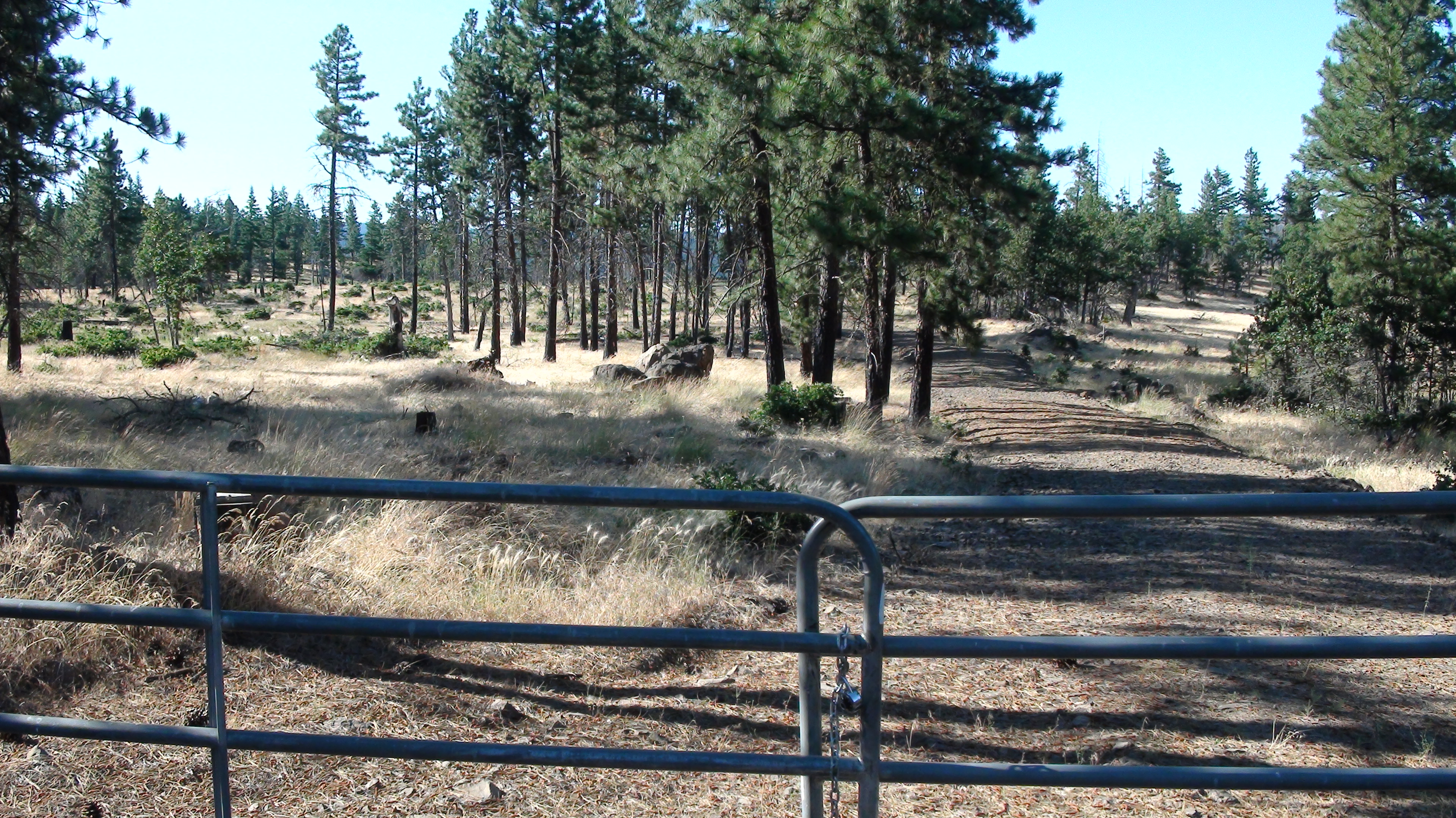
Ask me for the Padlock Combination